After two relaxing days at sea we began our first of four
port days at Hamilton Island. The island is one of only four inhabited islands
of the 74 islands that make up the Whitsunday Islands, all located within The
Great Barrier Reef National Park. Like everything else in this part of
Australia it seems, the Whitsundays were so named by Captain James Cook during
his mapping expedition of the east coast of what was then known as Terra
Australis Incognita, or "unknown southern land". He discovered the
islands on the English holiday of Whitsunday, hence the name. Except he forgot
about the 180 degree meridian, and he actually discovered them on Monday, so
technically they should be the Whitmonday Islands!!!!
Every cruise line that sails in the Caribbean has their own
"private island" where their ships call, usually a piece of land
leased from one of the Caribbean island countries. Hamilton Island is a private island in the truest sense of
the word, owned by the Oatley Family, a very wealthy Australian family. Back in
the 80's, a private developer came to Hamilton Island with a plan to develop a
vacation resort. After spending millions of dollars developing the island, he
ran into financial difficulties and the entire plan went into limbo. Along came
the Oatley Family, with $1.3 Billion rattling around in their pockets from the
sale of the family winery, Rosemount Wines, a name well known at the LCBO, and
bought the island. The rest is, as they say, history. The island contains two
five star resort hotels, complete with enormous (and open to the public)
swimming pools, an airport, a small retail area with shops and restaurants, and
an 18 hole championship golf course on nearby Dent Island.
We had originally booked a cruise of the Whitsunday Islands,
but unfortunately for us it was cancelled due to lack of interest. With only
500 people onboard there have been several cancelled tours, including three of
our first four. Rather than stay onboard, we decided to go ashore and have a
look around. There are no private cars allowed on the island other than service
vehicles and small shuttle buses. All other transportation is by means of golf
carts. All of the developed part is contained in a very small area, so getting
around by golf cart is quite easy. We took the free tour of the island by
shuttle bus, and it took a princely 15 minutes to complete.
 |
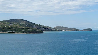
| This is Dent Island, across the channel from Hamilton Island. Also owned by the Oatleys, it is home to the Hamilton Island Golf Club. |
 |
| Hamilton Island - resorts and private residences. This is the town side, the beach side is to the left beyond the big hill. |
 |
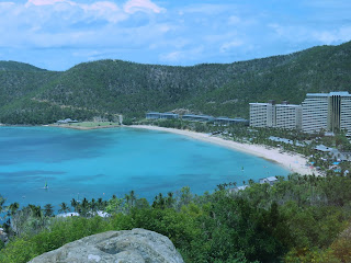
| Catseye Beach at the resort |
 |
| A look over Catseye Beach and the resort from our island tour |
 |
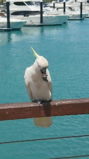
| A Sulphur-Crested Cockatoo stopped to grab a bite (literally from someone's plate) at the Marina |
 |
| Crystal Serenity at anchor off the island |
Our next stop was an overnight call in Cairns (pronounced Ceans
- like beans - by the locals. The "r" really is not silent, they just
don't pronounce it!), the largest city in Queensland State in the northeast
part of Australia, arriving just before Noon. We had been in Cairns for four
days as part of our land tour with Tauck in 2015, which left us with a small
problem. Reviewing the list of tours available over the day and a half, we
discovered we had done all but two of them, fortunately for us, one on each
day. Unfortunately for us, the one on the first afternoon was also cancelled,
so we spent the afternoon onboard, getting in our laps on the Promenade Deck and getting to the gym for the first time.
Our tour on Day 2, which was NOT cancelled, was The Kuranda
Scenic Railway and Rainforestation Nature Park. Cairns is located in a narrow
strip of land between the sea and the Great Barrier Mountains to the west,
making it a long, skinny city. The northern part contains the best beaches and
is heavily developed as a resort area, which is where we stayed in 2015, and
which attracts lots of visitors. The other attraction is eco-tourism centered on
the mountains behind the city. Kuranda is a small artists village located about
2,800 feet up and is accessible by road, Skyrail, a series of cable cars of
varying length, and by scenic train. When we were here in 2015, we visited
Kuranda by Skyrail, so this time we did it by rail. The line is narrow gauge
built in the 1800s during the gold rush. It was cut out of the rock and through
the mountain by hand over a period
of several years, including something in the neighbourhood of 30+ bridges and
two dozen tunnels, the longest some 470 metres long!! After the gold rush the
train was used to haul timber from the rain forests in the mountains. Today it
hauls tourists back and forth to those same mountains.
One thing we have not mentioned is that February and March
are the "wet" season in northeastern Australia. We came through a
number of heavy line squalls during our transit north from Sydney over the
previous four days, a pretty good shower before our tour left, and our tour
lived up to its name. The train took us up the mountain, into the forest, and
it rained. A LOT!!! And timed perfectly for our stop at the Barron River Falls
overlook, the only stop on the trip up!
 |
| The best picture we could get before it really started to rain! |
 |
| Surrounded by heavy vegetation - a lot of which only grows here in the Australian rain forest |
 |
| Elkhorn Fern - quite old and about 2 feet across! |
 |
| A Staghorn Fern - amazing to see in the rainforest |
 |
| On our way into the lake |
Rainforestation is the home of the Kuranda Wild Life Park.
Not really a park, more like a very small zoo whose major attraction is being
able to get a picture taken holding a Koala. Queensland is the only area in
Australia where one can actually hold a Koala, even thought the Koala is
actually not native to Queensland and is, as it were, brought in for the job.
Monica had her picture taken in 2015, so we didn't bother this time. We did
wander through the rest of the park which also has a number of indigenous
species, like the free range kangaroos below, and a couple of particularly mean
looking saltwater crocodiles!!
 |
| ...and they STILL needed the sign???? |
 |
| One of the kangaroos |
 |
| This one has a joey in her pouch |
 |
| A Koala doing what Koalas do best... |
Returning to the ship we considered going for a walk in "downtown" Cairns, but A) it was raining, B) it looked very threatening, and C) it was lunch time (!!), so we spent the rest of the afternoon onboard reading and doing our first load of laundry. We know, such an exciting life we lead!!
Our final Australian port stop was in Cooktown, located at
the point where the northeast coast turns left and becomes the north coast. Cooktown
owes its existence to the simple fact that Captain Cook's navigator gave him
bad directions and he ran his ship, the Endeavour, smack into a reef, holing
the hull! Needing to beach the Endeavour to make repairs, he ran it into the
Wabalumbaal River where he pitched camp and stayed for 47 days, his longest
stay in a single spot, along the way, naming everything, including re-naming
the river the Endeavour River! Naming the town Cooktown was a product of future
generations.
All you really need to know about Cooktown is that there
were only four tours offered, and they were morning and afternoon offerings of
the same two tours. Or as Rick Spath, the Cruise Director, put it, they added
morning and afternoon movies to the programme because there is nothing else to
do in Cooktown that would keep you ashore either before or after your tour!
Other than the Captain Cook Museum, there are two things to see
in Cooktown, the Black Mountain and the Lion Den Pub, and of those only the pub
is actually worth seeing. The best, and most stereotypical way, to describe it
would be what you would imagine Crocodile Dundee's local pub in the bush would
look like. Truth be told, it is located in the middle of nowhere, about an hour
from Cooktown, where the local ranchers gather to drink. They say a picture is
worth a thousand words, so here are a few thousand words.
 |
| Arriving at Cooktown - a foreboding for the day |
 |
| Our final destination |
 |
| Right across the road from Jim's Joint, one of the local ranches. If you look carefully on the left side of the photo, you will also find Lucy the Camel, a member of Jim's herd. |
 |
| We couldn't find a single square inch of wall or ceiling that didn't have some graffiti on it - we just signed the guest book |
 |
| A player piano, and the sign above was made entirely from coloured beer bottle caps! |
 |
| Looks like the kind of place Crocodile Dundee would wander into after a hard day's work |
 |
| The Endeavour River after the torrential rain and thunderstorm. It seemed to have risen since we drove over it the first time.. |
We got back to the tender pier just as, you guessed it, it
started to rain. Hard! Again! After a long and very warm ride in the tender, think
floating sauna (!!), we got back to the ship in time for Monica to get to art
class, and for Larry to write this blog post.


